
Share what you know,
and discover more.
Share what you know,
and discover more.
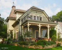

Frank and Elizabeth Raiter House
In the newspaper, the Messenger of August 12, 1882, the following notice appeared:_x000D_ _x000D_ "Frank Raiter is erecting the handsomest house to be found in the western part of the city. It is on the hill north of Myrtle street, and commands a fine view of the lake."_x000D_ _x000D_ No sooner had Frank built his house, but he had trouble with his neighbor to the north, a house owned by David Swain. The Messenger of September 30, 1882 has the story:_x000D_ _x000D_ "D.M. Swain was arrested last week on complaint of Frank Raiter for destroying a fence built by the latter between the elegant residence he is building and the house of Mr. Swain. Swain claiming that the fence destroyed was built on his (Swains) ground the case was dismissed, the municipal court being without power to pass on questions of title. The county attorney will present the case to the grand jury in November and ask that Swain be indicted for malicious destruction of property."_x000D_ _x000D_ Both Frank Raiter and his wife, Elizabeth ("Lizzie") were born in Sweden: he about 1842; she about 1845. Frank was the proprietor of a saloon, and the Wexio Hotel on North Second Street between Myrtle and Mulberry. He must have done well in the saloon/lodging business for he could afford to build this fancy house in 1882 at 115 North Harriet Street. In the 1891 Assessors records, his personal property was listed at $1,117, a considerable sum for that time._x000D_ _x000D_ Frank and Lizzie had two children living with them in their new house: Hattie, born in 1872, and George H., born in 1883._x000D_ _x000D_ Unfortunately, Frank did not get to enjoy his new house as long as he would have wished. He died on April 9, 1894 at the relatively young age of 54._x000D_ _x000D_ Lizzie remained in the house. In the 1900 U.S. Census she was living in the home with her two children, now 28 and 17 respectfully. George is working as a dry goods salesman. By the 1910 Census, she was living in the house alone._x000D_ _x000D_ By 1920, the house was duplexed with Lizzie in one part of the house, and the Linnell family (Elias W., Ida, his wife, and her mother, Sarah Jackson) living in another part of the house at 115 North Harriet Street. _x000D_ _x000D_ On January 18, 1928, Lizzie Raiter died, age 82. Through the 1930s, the house continued to function as a duplex under the ownership of Franks daughter, Hattie, and her husband, Charles Johnson, but in the 1940s, under the ownership of Dorothy and William Krog, it became a single family dwelling again. From 1950 to 1989 the residents were Willys and Ruth Jones; he was an investment banker in Minneapolis._x000D_ _x000D_ To this day, there remains a weathervane on the house with the letter, R.

Posted Date
Sep 27, 2021
Source Name
Heirloom Homes and Landmark


