


Share what you know,
and discover more.
Share what you know,
and discover more.
Mar 26, 2025

How I Tracked Down This Demolished Home's History and Address
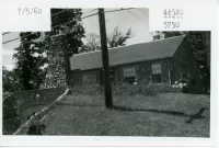
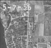
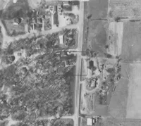
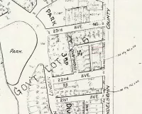
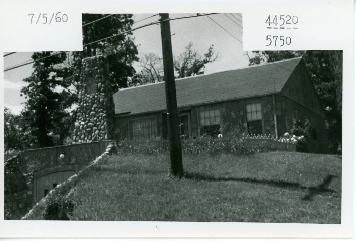
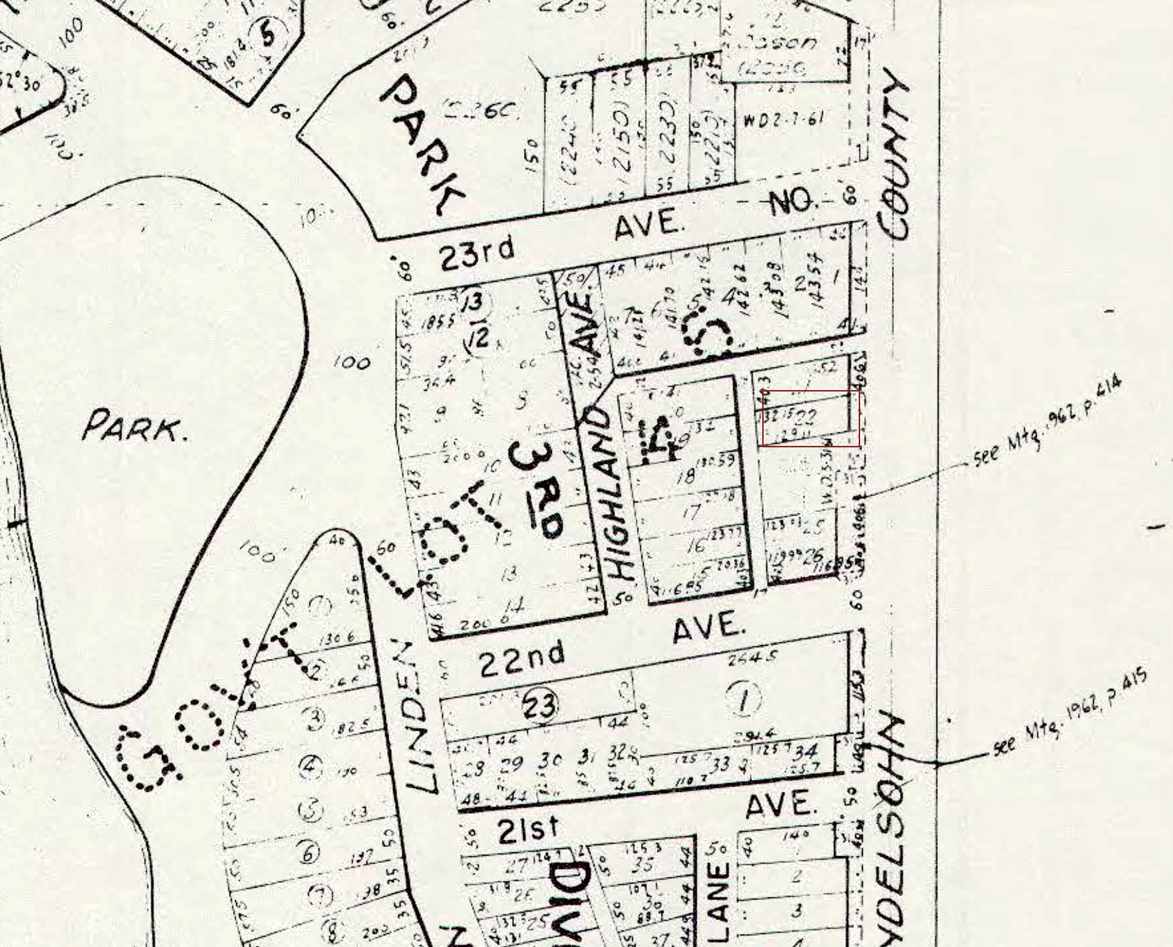
To begin solving the problem of where the house could be, I made note of all the information that was available. I then examined the picture of the house, and noted as many details as I could. The house sits on a small hill. I knew from the post that it was likely demolished for highway 169, and gauging from the power poles running so close to the house, the house itself was probably on a major road, which I guessed would be the future 169. The shadow from the utility pole in the front yard gave a pretty clear indication of the right side of the photo being the northern side. I noted the tuck-under garage, and determined that the drive probably went straight out to the highway which wasn’t far based on the utility poles. For the overall footprint and roof line I guessed it was probably a basic rectangle, and the large stone chimney was an outstanding feature. I familiarized myself a bit with the background of Plymouth Minnesota because I didn’t know anything about it other than it’s a suburb in the Twin Cities. I made note of any possible useful resources like the historical society and a local magazine. I knew the historical society was trying to find the house, everything they knew seemed to be in the listing, but it was good to have the information. In the post information I read that they thought that it was in the Plymouth Gardens area. I didn’t know where that was, and an internet search didn’t help. Given that it was historical, I accessed old newspapers and looked up Plymouth Gardens; there were some ads in 1922 for a “new suburb” for which a real estate company was selling land, but I could find no other information. There were descriptions of the location of the property which I noted. With this information I started on the aerial photographs. Using Google maps I acquainted myself with the area in the aerial photographs, so I could find where Highway 169 ended up. Looking in the Minnesota digital archives I found a phone book for Plymouth with a map from 1964, which let me know that it had started as County Road 18, and was also known as Mendelssohn Ave. Given that I knew that a suburb had been was being built in 1922 in the Medicine Lake area, not many miles from Minneapolis (information from the news ads,) I zeroed in on a clump of trees on one of the 1937 maps that looked about 20 years old. (It turned out that I was a little way north of Plymouth Gardens, but that saved me time examining the highway since I was closer to where I wanted to be!) I downloaded aerial photos of the suspected area for the several years available. In many the land was obscured by leaves on the trees, but in 1956 the pictures were taken when the leaves were off, and given that it wasn’t far from when the photo of the house was taken I paid extra close attention. From the orientation of the photo, I could confine my search to the west side of the highway for a house with a driveway off the county road. Comparing the aerial photo to the present day Google map, I could see that 169 took out houses on the west side of the county road between it and Kilmer (preserved as a road today,) and that the east side of the highway was pretty much untouched. I looked for similarities between both eras and found a house with a long driveway that appeared in both. Using it as a guidepost I scoured the map of 1956 County Road 18. A lot of the houses had dormer windows in the front so they were easily disqualified. Finally I spotted a house which had a short driveway and a large stone chimney on the southeast side, and I was confident that I found the house. Finding the address was another story. I looked in the phone book for any addresses on County Road 18, but none turned up in the 2100-2300 area. I had found a Hudson’s street map of “Minneapolis and Suburbs” from 1955, which listed all the old names of the streets that by 1964 had been renamed as numbered avenues. Given that the 1960 US census will not be fully digitized until 2032(!), I looked through the pertinent 1950 census pages. Having the old street names was a big help because I could follow the paths of the census takers which would have been impossible with a map from the ‘60s. I found surveys from the relevant area and tried to find the mystery house, but although there were addresses for the streets I was looking for I didn’t see any on County Road 18. Looking at the aerial maps it does appear that it was one of the only houses with a driveway out to 18. Nothing was panning out in the census survey, until I reached the back pages. It appeared to me that the back pages had “make up” surveys, houses in which no one was home when they first went through; the street addresses became scattered and I could tell they were going back over the places they’d been. It was in here that I found a listing for “Zone 22 Co R 18”. This was very promising! Is that what the inhabitant told the census taker was their address? All other entries had “normal” house numbers with street names. I made a note of the family on the survey and looked in the 1964 phone book. The name existed, but the address was listed as 1225 Co Rd 18. This made little sense since the number was so low. In my research I had downloaded the historical property maps of the area. It occurred to me that the lot number of the mystery house was 22, Zone 22 Co R 18 was looking better all the time. But what about the family, did they move from the mystery house further south on 18 by 1964? It was 14 years later, so maybe. I googled the homeowner’s name and found an obituary from when the head of the house died in 1963. The address listed was the same as in the phone book, 1225 Co Rd 18. So that wasn’t super helpful. I tried to find addresses for the houses across the street from the mystery house, but directly across was a farm building, and the street numbers in Golden Valley followed the numbers in Plymouth anyway. So again I thought that the closest I’d get is the address from the 1950 census. But it bothered me that the address listed for the family in 1963 and 1964 was 1225, and I chased that dog a bit more. I looked at the aerial maps for a house on 18 at approximately 12th avenue. By this time I knew that Plymouth Gardens was a small neighborhood of about four blocks down 18 (it doesn’t look like it took off, only 9th and 10th avenue seemed populated.) I scrolled up to about where 12th avenue should be, given that I knew that there was a break of uninhabited land between 10th Avenue and 17th Avenue. There did seem to be a small driveway there, and a house set back from 18 a bit. So I’m not sure if it would have an address on County Road 18. However, I examined the 1940 and 1953 aerial maps for the area and there was already a house there that was set quite close to the road, so perhaps the address was inherited when the new construction took place? At any rate, it was a plausible explanation for 1225 County Road 18. So to sum up, the closest thing to an address I was able to find is “Zone 22 Co Rd 18.” It was inhabited by Henry Paetzel and his wife and daughter in 1950, and between then and 1963 they moved south on 18. The house was built sometime between 1945-1953. By 1967 the Mystery House was gone, along with its neighboring houses, as the area along 18 was widened for the upcoming Highway 169.
How I Tracked Down This Demolished Home's History and Address
To begin solving the problem of where the house could be, I made note of all the information that was available. I then examined the picture of the house, and noted as many details as I could. The house sits on a small hill. I knew from the post that it was likely demolished for highway 169, and gauging from the power poles running so close to the house, the house itself was probably on a major road, which I guessed would be the future 169. The shadow from the utility pole in the front yard gave a pretty clear indication of the right side of the photo being the northern side. I noted the tuck-under garage, and determined that the drive probably went straight out to the highway which wasn’t far based on the utility poles. For the overall footprint and roof line I guessed it was probably a basic rectangle, and the large stone chimney was an outstanding feature. I familiarized myself a bit with the background of Plymouth Minnesota because I didn’t know anything about it other than it’s a suburb in the Twin Cities. I made note of any possible useful resources like the historical society and a local magazine. I knew the historical society was trying to find the house, everything they knew seemed to be in the listing, but it was good to have the information. In the post information I read that they thought that it was in the Plymouth Gardens area. I didn’t know where that was, and an internet search didn’t help. Given that it was historical, I accessed old newspapers and looked up Plymouth Gardens; there were some ads in 1922 for a “new suburb” for which a real estate company was selling land, but I could find no other information. There were descriptions of the location of the property which I noted. With this information I started on the aerial photographs. Using Google maps I acquainted myself with the area in the aerial photographs, so I could find where Highway 169 ended up. Looking in the Minnesota digital archives I found a phone book for Plymouth with a map from 1964, which let me know that it had started as County Road 18, and was also known as Mendelssohn Ave. Given that I knew that a suburb had been was being built in 1922 in the Medicine Lake area, not many miles from Minneapolis (information from the news ads,) I zeroed in on a clump of trees on one of the 1937 maps that looked about 20 years old. (It turned out that I was a little way north of Plymouth Gardens, but that saved me time examining the highway since I was closer to where I wanted to be!) I downloaded aerial photos of the suspected area for the several years available. In many the land was obscured by leaves on the trees, but in 1956 the pictures were taken when the leaves were off, and given that it wasn’t far from when the photo of the house was taken I paid extra close attention. From the orientation of the photo, I could confine my search to the west side of the highway for a house with a driveway off the county road. Comparing the aerial photo to the present day Google map, I could see that 169 took out houses on the west side of the county road between it and Kilmer (preserved as a road today,) and that the east side of the highway was pretty much untouched. I looked for similarities between both eras and found a house with a long driveway that appeared in both. Using it as a guidepost I scoured the map of 1956 County Road 18. A lot of the houses had dormer windows in the front so they were easily disqualified. Finally I spotted a house which had a short driveway and a large stone chimney on the southeast side, and I was confident that I found the house. Finding the address was another story. I looked in the phone book for any addresses on County Road 18, but none turned up in the 2100-2300 area. I had found a Hudson’s street map of “Minneapolis and Suburbs” from 1955, which listed all the old names of the streets that by 1964 had been renamed as numbered avenues. Given that the 1960 US census will not be fully digitized until 2032(!), I looked through the pertinent 1950 census pages. Having the old street names was a big help because I could follow the paths of the census takers which would have been impossible with a map from the ‘60s. I found surveys from the relevant area and tried to find the mystery house, but although there were addresses for the streets I was looking for I didn’t see any on County Road 18. Looking at the aerial maps it does appear that it was one of the only houses with a driveway out to 18. Nothing was panning out in the census survey, until I reached the back pages. It appeared to me that the back pages had “make up” surveys, houses in which no one was home when they first went through; the street addresses became scattered and I could tell they were going back over the places they’d been. It was in here that I found a listing for “Zone 22 Co R 18”. This was very promising! Is that what the inhabitant told the census taker was their address? All other entries had “normal” house numbers with street names. I made a note of the family on the survey and looked in the 1964 phone book. The name existed, but the address was listed as 1225 Co Rd 18. This made little sense since the number was so low. In my research I had downloaded the historical property maps of the area. It occurred to me that the lot number of the mystery house was 22, Zone 22 Co R 18 was looking better all the time. But what about the family, did they move from the mystery house further south on 18 by 1964? It was 14 years later, so maybe. I googled the homeowner’s name and found an obituary from when the head of the house died in 1963. The address listed was the same as in the phone book, 1225 Co Rd 18. So that wasn’t super helpful. I tried to find addresses for the houses across the street from the mystery house, but directly across was a farm building, and the street numbers in Golden Valley followed the numbers in Plymouth anyway. So again I thought that the closest I’d get is the address from the 1950 census. But it bothered me that the address listed for the family in 1963 and 1964 was 1225, and I chased that dog a bit more. I looked at the aerial maps for a house on 18 at approximately 12th avenue. By this time I knew that Plymouth Gardens was a small neighborhood of about four blocks down 18 (it doesn’t look like it took off, only 9th and 10th avenue seemed populated.) I scrolled up to about where 12th avenue should be, given that I knew that there was a break of uninhabited land between 10th Avenue and 17th Avenue. There did seem to be a small driveway there, and a house set back from 18 a bit. So I’m not sure if it would have an address on County Road 18. However, I examined the 1940 and 1953 aerial maps for the area and there was already a house there that was set quite close to the road, so perhaps the address was inherited when the new construction took place? At any rate, it was a plausible explanation for 1225 County Road 18. So to sum up, the closest thing to an address I was able to find is “Zone 22 Co Rd 18.” It was inhabited by Henry Paetzel and his wife and daughter in 1950, and between then and 1963 they moved south on 18. The house was built sometime between 1945-1953. By 1967 the Mystery House was gone, along with its neighboring houses, as the area along 18 was widened for the upcoming Highway 169.
Mar 26, 2025
Jan 01, 1967

Jan 01, 1967


Posted Date
Apr 24, 2025
Historical Record Date
Jan 01, 1967
Source Name
Ryan Barland, Historical Site Coordinator for the City of Plymouth
Document Source
Nov 01, 1960

Plymouth changes street names
The street names in the Plymouth Gardens area of Plymouth, Minnesota, were officially changed on November 1, 1960, when the Village Council passed Ordinance No. 60-10. This ordinance aimed to standardize street naming and property numbering across the village. docs.plymouthmn.gov According to the ordinance, several streets in the Plymouth Gardens area were renamed: Norwalk → Lancaster Lane Schubert → Lancaster Lane Unter Den Linden → Lancaster Lane Erie → Nathan Lane Liszt → Nathan Lane Meyerbeer → Orleans Lane Teal Lane → Pilgrim Lane Harmonia → Pilgrim Lane Mallard → Quaker Lane 102nd → Quaker Lane The ordinance also established a naming convention: streets running north-south would be designated with names ending in "Lane," while east-west streets would be numbered avenues. This renaming was part of a broader effort to bring uniformity to the village's street system and to facilitate property numbering Sources include: -Recorded street name changes: https://docs.plymouthmn.gov/WebLink/DocView.aspx?dbid=0&id=24596&repo=Plymouth&utm_source=chatgpt.com&cr=1 -Original street names: https://digitalcollections.hclib.org/digital/collection/p17208coll17/id/1891/
Nov 01, 1960


Posted Date
Apr 24, 2025
Historical Record Date
Nov 01, 1960
Source Name
Multiple sources; see story description