Share what you know,
and discover more.
Share what you know,
and discover more.
Oct 08, 2009

Roos House - National Register of Historic Places
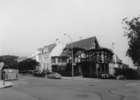
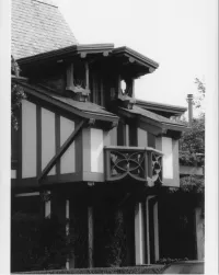
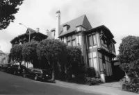
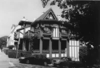
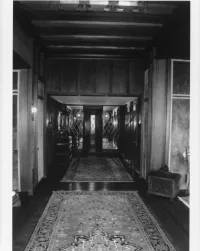
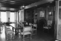
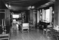
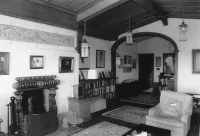
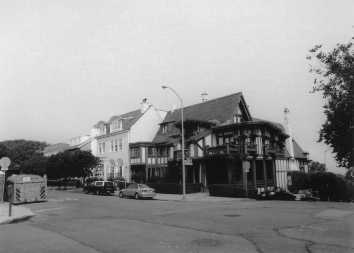
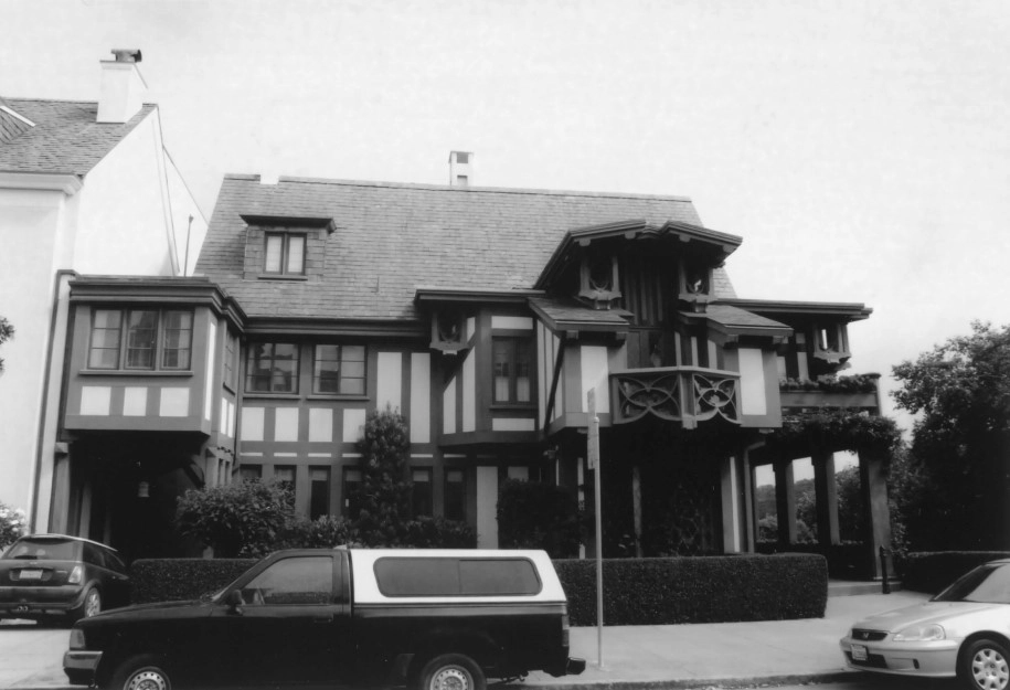
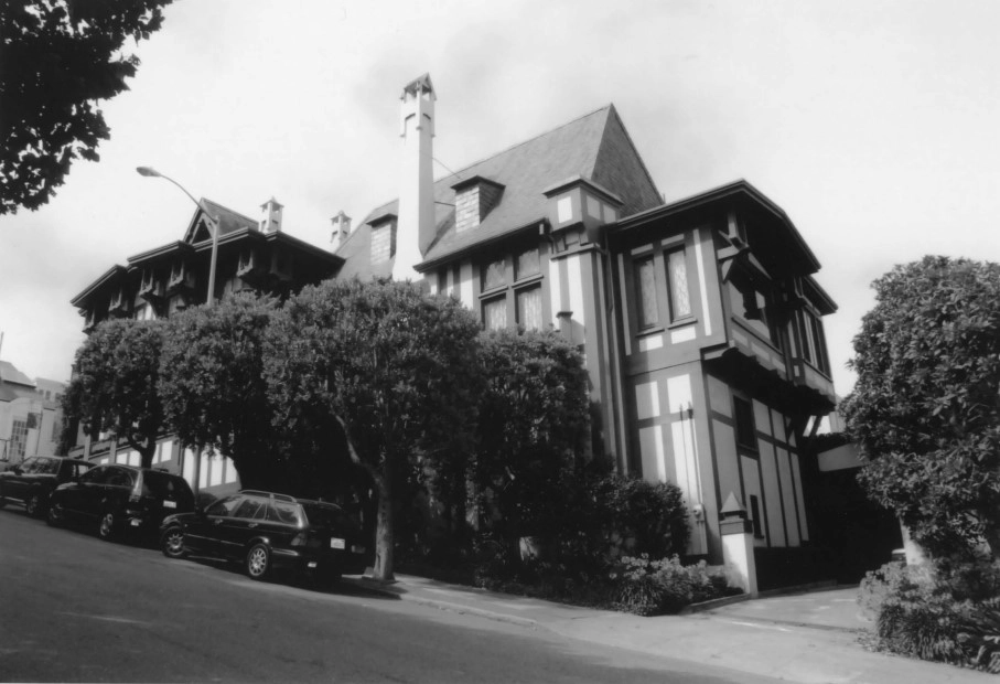
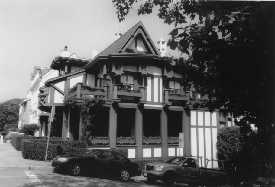
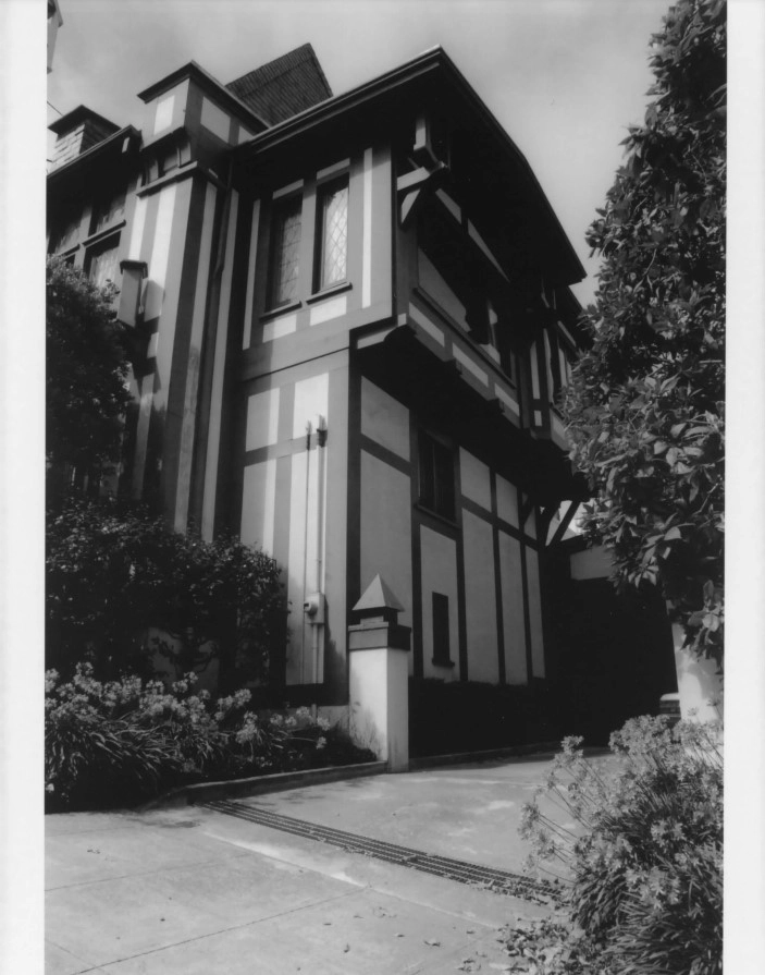
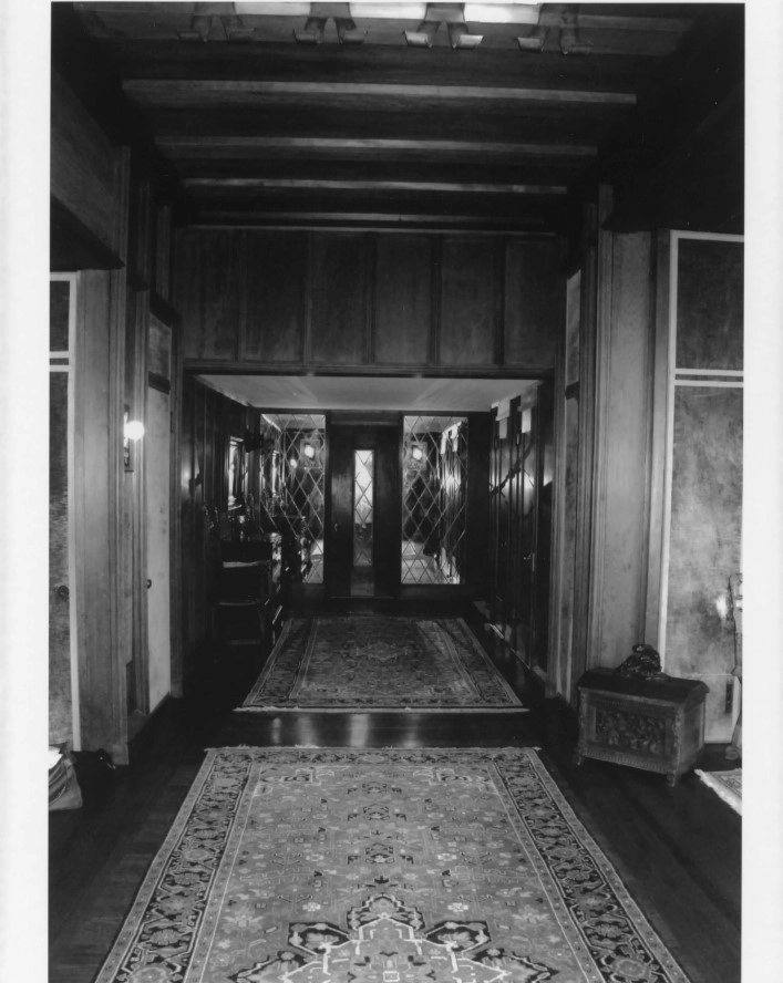
Statement of Significance The Roos House is an exceptional example of the work of nationally prominent master architect, Bernard Maybeck. It embodies the distinctive characteristics of Tudor Revival style of architecture as interpreted by Maybeck and possesses high artistic value in its complex massing and intricate Gothic decorative details. The Roos house meets National Register Criterion C in the area of Architecture and retains integrity of location, design, setting, materials, workmanship, feeling and association. The period of significance for the Roos House is 1909-1926, encompassing the original design and construction of the house, as well as all later alterations, which were also the work of Maybeck. History of Presidio Heights Presidio Heights, which is the area roughly bounded by Presidio Avenue, California Street, Anguello Boulevard, and Pacific Avenue, is an affluent residential district in the western portion of San Francisco. When the Spanish established the Presidio, the area immediately surrounding the settlement was a vast expanse of sand dunes and chaparral, and it remained relatively unsettled until well after the Gold Rush. In 1846, Pio Pico, the last Mexican governor, granted Rancho Punta de Los Lobos to Benito Diaz. Diaz left his lands, which encompassed what is now the Richmond District, unimproved, and except for a few squatters, no one showed any interest in settling this remote part of the city until the 1870s. In the 1850s, the city annexed the Western Addition, a tract encompassing five hundred blocks between Larkin and Divisadero Streets, under the Van Ness Ordinance. This ordinance gave land ownership rights to squatters who had been living in the Western Addition, including what is now Pacific Heights (located just to the east of Presidio Heights). Between the 1850s and the 1870s, Pacific Heights was sparsely developed, and with only one graded street into the area, access was difficult until the early 1870s. Hoping to further facilitate the development of the outer reaches of the city, the Board of Supervisors passed the Clement and Outside Lands Ordinances in 1866 and 1868, respectively. These ordinances provided means to settle land claims and set aside public lands for parks in all un surveyed “outside lands” within the city’s corporate boundaries, which included the Richmond, Mission, and Potrero Districts, among others. An “Official Map of the Outside Lands” was published in 1870, extending the street grid of downtown and the Western Addition into Presidio Heights and the Richmond. By the turn ofthe century, San Francisco’s rectangular street grid had been extended all the way to the ocean. However, transportation issues still hindered the development ofthe western neighborhoods. Public transportation was provided by Antoine Borel (1840-1915)—a Swiss immigrant who was one ofthe city’s most successful early businessmen—and Adolph Sutro (1830-1898)—a banker and real estate magnate who served as the city’s 24“’ mayor and owned most of the land west of Twin Peaks—each of whom had built electric railroad lines that extended to this part of the city by 1896.^ Grading the streets was another important task that had to be completed before the western neighborhoods could become a fully populated residential district. In the late nineteenth century, the responsibility for grading and paving fell on the local landowners. According to a November 1, 1889, article in the San Francisco Examiner, Geary and Arguello boulevards were the first streets in the area to be paved. Sewage, water, and electricity soon followed, and by the turn of the century development was clustered around the principal transportation lines along California Street, Gear Boulevard, Arguello Boulevard, and others." After the 1906 Earthquake and Fire, most of downtown San Francisco, the South of Market Area, and parts of the Western Addition and the Mission were in ruins, and many San Franciscans sought refuge in the empty parcels on the city’s western edge. Many parcels were subdivided after the disaster, and houses of all shapes and sizes began to appear in Presidio Heights and the Richmond District. Upscale development in Presidio Heights spread westward from Pacific Heights after the earthquake, and due to its proximity to good public transportation along California Street, Presidio Heights was established as an especially fashionable neighborhood. The increased popularity of the automobile also helped encourage the development of Presidio Heights and surrounding neighborhoods, such as Laurel Heights, Pacific Heights, Presidio Terrace, and the Richmond District, and by the late 1920s, these neighborhoods had been largely built out with single-family homes with automobile garages. Tudor Revival Style Architecture Tudor Revival was a popular architectural style in the United State in the early 20th century. Deriving its inspiration from early England, Tudor Revival buildings are reminiscent of buildings from the 16th-century Tudor monarchy. Tudor Revival buildings are known for steep, multicable roofs that feature massive chimneys, constructed of brick or stone and capped with elaborate chimney pots. The exteriors are clad in brick, stone, or stucco and feature decorative half-timbering. Mullioned windows are grouped in two, three or four, and most often have casement sashes as opposed to double-hung. The windows are often glazed with leaded glass that is multi-paned, with panes sometimes arranged in a diamond pattern. The entryways are often arched and surrounded by decorative brick or stone work. The Roos House exhibits the characteristics of Tudor Revival style; however, it is Maybeck’s personal interpretation of this style, rather than a more faithful revival interpretation.
Roos House - National Register of Historic Places
Statement of Significance The Roos House is an exceptional example of the work of nationally prominent master architect, Bernard Maybeck. It embodies the distinctive characteristics of Tudor Revival style of architecture as interpreted by Maybeck and possesses high artistic value in its complex massing and intricate Gothic decorative details. The Roos house meets National Register Criterion C in the area of Architecture and retains integrity of location, design, setting, materials, workmanship, feeling and association. The period of significance for the Roos House is 1909-1926, encompassing the original design and construction of the house, as well as all later alterations, which were also the work of Maybeck. History of Presidio Heights Presidio Heights, which is the area roughly bounded by Presidio Avenue, California Street, Anguello Boulevard, and Pacific Avenue, is an affluent residential district in the western portion of San Francisco. When the Spanish established the Presidio, the area immediately surrounding the settlement was a vast expanse of sand dunes and chaparral, and it remained relatively unsettled until well after the Gold Rush. In 1846, Pio Pico, the last Mexican governor, granted Rancho Punta de Los Lobos to Benito Diaz. Diaz left his lands, which encompassed what is now the Richmond District, unimproved, and except for a few squatters, no one showed any interest in settling this remote part of the city until the 1870s. In the 1850s, the city annexed the Western Addition, a tract encompassing five hundred blocks between Larkin and Divisadero Streets, under the Van Ness Ordinance. This ordinance gave land ownership rights to squatters who had been living in the Western Addition, including what is now Pacific Heights (located just to the east of Presidio Heights). Between the 1850s and the 1870s, Pacific Heights was sparsely developed, and with only one graded street into the area, access was difficult until the early 1870s. Hoping to further facilitate the development of the outer reaches of the city, the Board of Supervisors passed the Clement and Outside Lands Ordinances in 1866 and 1868, respectively. These ordinances provided means to settle land claims and set aside public lands for parks in all un surveyed “outside lands” within the city’s corporate boundaries, which included the Richmond, Mission, and Potrero Districts, among others. An “Official Map of the Outside Lands” was published in 1870, extending the street grid of downtown and the Western Addition into Presidio Heights and the Richmond. By the turn ofthe century, San Francisco’s rectangular street grid had been extended all the way to the ocean. However, transportation issues still hindered the development ofthe western neighborhoods. Public transportation was provided by Antoine Borel (1840-1915)—a Swiss immigrant who was one ofthe city’s most successful early businessmen—and Adolph Sutro (1830-1898)—a banker and real estate magnate who served as the city’s 24“’ mayor and owned most of the land west of Twin Peaks—each of whom had built electric railroad lines that extended to this part of the city by 1896.^ Grading the streets was another important task that had to be completed before the western neighborhoods could become a fully populated residential district. In the late nineteenth century, the responsibility for grading and paving fell on the local landowners. According to a November 1, 1889, article in the San Francisco Examiner, Geary and Arguello boulevards were the first streets in the area to be paved. Sewage, water, and electricity soon followed, and by the turn of the century development was clustered around the principal transportation lines along California Street, Gear Boulevard, Arguello Boulevard, and others." After the 1906 Earthquake and Fire, most of downtown San Francisco, the South of Market Area, and parts of the Western Addition and the Mission were in ruins, and many San Franciscans sought refuge in the empty parcels on the city’s western edge. Many parcels were subdivided after the disaster, and houses of all shapes and sizes began to appear in Presidio Heights and the Richmond District. Upscale development in Presidio Heights spread westward from Pacific Heights after the earthquake, and due to its proximity to good public transportation along California Street, Presidio Heights was established as an especially fashionable neighborhood. The increased popularity of the automobile also helped encourage the development of Presidio Heights and surrounding neighborhoods, such as Laurel Heights, Pacific Heights, Presidio Terrace, and the Richmond District, and by the late 1920s, these neighborhoods had been largely built out with single-family homes with automobile garages. Tudor Revival Style Architecture Tudor Revival was a popular architectural style in the United State in the early 20th century. Deriving its inspiration from early England, Tudor Revival buildings are reminiscent of buildings from the 16th-century Tudor monarchy. Tudor Revival buildings are known for steep, multicable roofs that feature massive chimneys, constructed of brick or stone and capped with elaborate chimney pots. The exteriors are clad in brick, stone, or stucco and feature decorative half-timbering. Mullioned windows are grouped in two, three or four, and most often have casement sashes as opposed to double-hung. The windows are often glazed with leaded glass that is multi-paned, with panes sometimes arranged in a diamond pattern. The entryways are often arched and surrounded by decorative brick or stone work. The Roos House exhibits the characteristics of Tudor Revival style; however, it is Maybeck’s personal interpretation of this style, rather than a more faithful revival interpretation.
Oct 08, 2009


Posted Date
Apr 12, 2022
Historical Record Date
Oct 08, 2009
Source Name
United States Department of Interior - National Park Service