Share what you know,
and discover more.
Share what you know,
and discover more.
Sep 01, 2011


Sep 01, 2011

Posted Date
Apr 23, 2024
Historical Record Date
Sep 01, 2011
Source Name
Google Maps
Jun 01, 1854
Jun 01, 1854
Office of U.S. Surveyor General
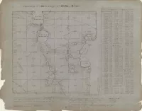
The survey from 1854 shows the area that is now south Minneapolis into Edina. More about the survey: The Land Ordinance Act of 1785 established the rectangular survey system, later named the Public Land Survey System (PLSS), dividing western lands into grid-like townships and sections. This system facilitated the sale of surveyed land by the government, generating crucial revenue. Prior to the PLSS, a confusing landmark-based system called metes and bounds was used. The PLSS relies on coordinates, with distances and bearings measured from north-south meridians and east-west base lines. The primary unit of land division is the Public Land Survey Township, each measuring six miles square and containing 36 sections, each one square mile (640 acres). The Office of U.S. Surveyor General, established in 1796, oversaw land surveys as the nation expanded westward. It was later placed under the General Land Office (GLO) in 1836, then the Department of Interior in 1849. In 1925, the Surveyor General's office closed, and surveying duties were absorbed by the GLO, which was eventually abolished in 1946, with its functions transferred to the Bureau of Land Management (BLM). In Minnesota, early surveys were conducted by the Surveyor General of Iowa and Wisconsin. The Office of Surveyor General of Minnesota was established in 1857, overseeing land surveys in the territory and state. Land east of the Mississippi was surveyed from the Galena Base Line, while land west of the Mississippi was surveyed from the Clarendon Base Line. Survey contracts were awarded competitively to deputy surveyors, who conducted field work with crews, marking boundaries and recording measurements. Distances were measured using chains and links, with alignment determined by compasses. Monuments were placed at township and section corners, often with "bearing trees" nearby. In areas where chains couldn't be used, distances were calculated using triangulation. Deputy surveyors also mapped physical features like lakes, rivers, and forests, noting soil type and vegetation in field notes. These records, now digitized, provide detailed information and are accessible online and preserved by the Minnesota State Archives.
Office of U.S. Surveyor General
The survey from 1854 shows the area that is now south Minneapolis into Edina. More about the survey: The Land Ordinance Act of 1785 established the rectangular survey system, later named the Public Land Survey System (PLSS), dividing western lands into grid-like townships and sections. This system facilitated the sale of surveyed land by the government, generating crucial revenue. Prior to the PLSS, a confusing landmark-based system called metes and bounds was used. The PLSS relies on coordinates, with distances and bearings measured from north-south meridians and east-west base lines. The primary unit of land division is the Public Land Survey Township, each measuring six miles square and containing 36 sections, each one square mile (640 acres). The Office of U.S. Surveyor General, established in 1796, oversaw land surveys as the nation expanded westward. It was later placed under the General Land Office (GLO) in 1836, then the Department of Interior in 1849. In 1925, the Surveyor General's office closed, and surveying duties were absorbed by the GLO, which was eventually abolished in 1946, with its functions transferred to the Bureau of Land Management (BLM). In Minnesota, early surveys were conducted by the Surveyor General of Iowa and Wisconsin. The Office of Surveyor General of Minnesota was established in 1857, overseeing land surveys in the territory and state. Land east of the Mississippi was surveyed from the Galena Base Line, while land west of the Mississippi was surveyed from the Clarendon Base Line. Survey contracts were awarded competitively to deputy surveyors, who conducted field work with crews, marking boundaries and recording measurements. Distances were measured using chains and links, with alignment determined by compasses. Monuments were placed at township and section corners, often with "bearing trees" nearby. In areas where chains couldn't be used, distances were calculated using triangulation. Deputy surveyors also mapped physical features like lakes, rivers, and forests, noting soil type and vegetation in field notes. These records, now digitized, provide detailed information and are accessible online and preserved by the Minnesota State Archives.

Posted Date
Apr 23, 2024
Historical Record Date
Jun 01, 1854
Source Name
GLO Historic Plat Map Retrieval System